Planning a trip to Vancouver Island from the United States? Understanding its geography with a detailed map is essential for any U.S. traveler. This comprehensive guide helps you pinpoint Vancouver Island's location, identify key cities like Victoria and Nanaimo, and navigate its many attractions. Discover crucial ferry routes from mainland British Columbia and Washington State, explore scenic drives, and locate stunning natural parks. Whether you are searching for the best routes to Tofino, mapping out whale watching tours from Telegraph Cove, or finding the perfect hiking trails near Comox Valley, a good Vancouver Island map is your indispensable tool. Learn about major highways, smaller regional roads, and how to effectively use a map to plan your itinerary, find accommodations, and experience everything this incredible Canadian island offers. Make your journey stress free by knowing exactly where you are going and what adventures await you across the island's diverse landscapes. This guide is tailored for U.S. visitors seeking practical travel information and navigational clarity for their Vancouver Island adventure.
- How long does it take to drive across Vancouver Island? - Driving from Victoria at the southern tip to Port Hardy in the north typically takes about 6 to 8 hours without significant stops. However, this varies based on traffic, road conditions, and the specific route chosen. Factor in extra time for scenic viewpoints, ferry schedules, and exploring towns along the way.
- What are the best ferry routes to Vancouver Island from the US? - The most direct ferry route from the U.S. is the MV Coho, traveling from Port Angeles, Washington, to Victoria, British Columbia. Another common option involves driving to Seattle or Bellingham, Washington, and then taking a ferry operated by Washington State Ferries to Sidney (near Victoria) or using BC Ferries from Vancouver, BC.
- Is a GPS necessary for driving on Vancouver Island? - While a GPS or smartphone navigation is helpful for real-time directions and finding specific addresses, a physical road map is also highly recommended. Cell service can be unreliable in more remote areas of Vancouver Island, making a traditional map a crucial backup for continuous navigation.
- Can I find attractions like Butchart Gardens on a Vancouver Island map? - Yes, major attractions such as Butchart Gardens near Victoria, Pacific Rim National Park Reserve, and various provincial parks are clearly marked on most detailed Vancouver Island travel maps. These maps help you plan your route to these sites and understand their proximity to other points of interest.
- What is the main highway on Vancouver Island? - The main transportation artery on Vancouver Island is the Island Highway, which consists of Highway 1 (Trans-Canada Highway) in the south and Highway 19 (Vancouver Island Highway) farther north. These highways connect many of the island's major communities and provide primary access for driving throughout the island.
- Are there maps specifically for hiking trails on Vancouver Island? - Yes, for hiking and outdoor activities, specialized topographic maps are available for Vancouver Island's many parks and wilderness areas. National and provincial park visitor centers often provide detailed trail maps, and dedicated outdoor recreation stores also carry these more detailed navigational tools for specific regions.
- Does Vancouver Island have a public transport map? - Each major city and region on Vancouver Island has its own local public transit system, like BC Transit, with specific route maps available online and at bus stops. While there isn't one single island-wide public transport map, you can find localized maps for Victoria, Nanaimo, Comox Valley, and other areas to navigate within those communities.
How do I get to Vancouver Island from the US?
U.S. visitors can reach Vancouver Island by taking a direct ferry from Port Angeles, Washington, to Victoria, British Columbia. Alternatively, you can drive to Vancouver, BC, and then take a BC Ferries vessel to Nanaimo or Victoria. Flights are also available from major U.S. cities to Victoria International Airport (YYJ) or Nanaimo Airport (YCD).
What are the main cities on Vancouver Island?
The main cities on Vancouver Island include Victoria, the provincial capital located at the southern tip; Nanaimo, a central hub with ferry access; Courtney and Comox in the central region; Campbell River further north; and the popular surf towns of Tofino and Ucluelet on the west coast. Each city offers unique attractions and serves as a base for exploring surrounding areas.
Is Vancouver Island part of Canada?
Yes, Vancouver Island is part of Canada. It is located in the province of British Columbia, off the country's Pacific coast. Despite its name, which often leads to confusion with the city of Vancouver on the mainland, Vancouver Island is a distinct geographical entity and a significant part of Canadian territory.
What kind of map should I use for Vancouver Island travel?
For Vancouver Island travel, a combination of maps is best. A detailed physical road map provides an excellent overview for planning, especially where cell service is limited. Digital maps on smartphones or GPS devices offer real-time navigation and updates. For outdoor adventures, consider topographic maps for parks and wilderness areas, or marine charts for coastal activities.
Can I drive around Vancouver Island?
Yes, you can absolutely drive around Vancouver Island. The island has an extensive road network, including major highways like the Island Highway (Highway 19 and 19A) that runs much of its length, connecting key cities and towns. Many scenic drives and smaller roads lead to provincial parks, coastal communities, and other attractions, making a road trip a popular way to explore.
Navigating Vancouver Island: Your Essential Map GuideVancouver Island, a jewel off Canada's Pacific coast, draws countless U.S. travelers each year with its rugged beauty, vibrant cities, and diverse ecosystems. Understanding its layout with a reliable map is the first step toward a memorable adventure. Whether you are planning a road trip along the scenic coasts or exploring its charming towns, a detailed map helps you visualize distances, identify key landmarks, and discover hidden gems.
This guide offers practical insights into using a Vancouver Island map effectively, ensuring U.S. visitors can confidently plan their journey. We will cover everything from understanding its geographical placement to locating popular destinations and crucial transportation links. Get ready to unlock the full potential of your Vancouver Island experience with the right navigational tools at your fingertips.
Knowing where you are and where you want to go on Vancouver Island transforms a good trip into a truly great one. From the bustling capital of Victoria in the south to the wild remote stretches of the north, a map provides clarity and direction, making your travel seamless and enjoyable. Prepare to explore one of North America's most enchanting islands with confidence.
Where is Vancouver Island Located?
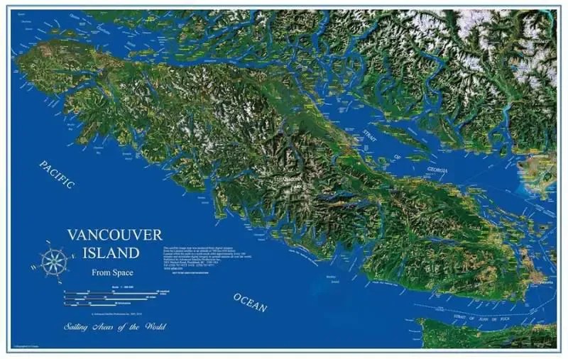
Vancouver Island sits off the southwestern coast of British Columbia, Canada, separated from the mainland by the Strait of Georgia and Johnstone Strait. For U.S. travelers, its proximity to Washington State makes it an accessible international destination. The island is part of Canada, despite its name often causing confusion with the city of Vancouver on the mainland.
Its strategic location makes it a gateway to the Pacific Rim, offering a unique blend of coastal wilderness and urban sophistication. From major U.S. cities like Seattle or Portland, reaching Vancouver Island involves either a ferry ride or a flight, with maps being indispensable for planning these connections. Knowing its exact location helps in estimating travel times and choosing the most convenient entry points.
The island stretches approximately 290 miles (460 kilometers) from north to south and 60 miles (100 kilometers) at its widest point. It is the largest island on the west coast of North America. Its sheer size means a good map is crucial for navigating its varied terrain, from the mountainous spine to the countless inlets and beaches along its extensive coastline.
Getting to Vancouver Island from the U.S.
U.S. visitors have several options for reaching Vancouver Island, and a map is key for plotting the best route. The most popular method is by ferry. You can take a direct ferry from Port Angeles, Washington, to Victoria, British Columbia, aboard the MV Coho. Another option involves driving north to Vancouver, BC, and then taking a BC Ferries vessel from Tsawwassen or Horseshoe Bay to Nanaimo or Victoria.
For those preferring to fly, flights are available from major U.S. cities to Victoria International Airport (YYJ) or Nanaimo Airport (YCD). Once you arrive, a detailed map helps you find rental car services, navigate to your accommodation, and begin your exploration of the island's diverse regions. Planning your arrival and subsequent travel with a map ensures a smooth transition to your island adventure.
Each travel method presents different logistical considerations, and a map helps visualize the journey. Whether you are bringing your car on a ferry or renting one upon arrival, understanding the road network, major highways, and ferry terminal locations is vital. Maps provide the necessary visual information to make informed decisions about your travel path, helping you connect the dots from your U.S. starting point to your desired destination on Vancouver Island.
Exploring Major Cities on Vancouver Island Maps
Vancouver Island is home to several prominent cities, each offering unique attractions, and finding them on a map is straightforward. Victoria, the provincial capital, is located at the southern tip. Its inner harbor, historic architecture, and vibrant cultural scene are easily identifiable on any detailed map. North of Victoria, Nanaimo serves as a central hub, known for its harbor and convenient ferry access to the mainland. Both cities are critical points on any map for U.S. travelers.
Further north, cities like Courtney, Comox, and Campbell River provide access to outdoor activities, from skiing at Mount Washington to salmon fishing. A map highlights their positions along the island's main highway, the Island Highway (Highway 19 and 19A), making it simple to plan stops between destinations. These cities often serve as gateways to smaller, more remote communities and natural parks, all easily located with a good map.
On the island's wild west coast, Tofino and Ucluelet stand out as popular surf towns and wildlife viewing destinations. A map will show their relatively isolated locations, emphasizing the scenic drives required to reach them, often through old-growth forests and alongside breathtaking coastlines. Understanding the layout of these major cities and their connections is essential for U.S. visitors planning to explore the full breadth of Vancouver Island's offerings.
What Type of Map is Best for Vancouver Island Travel?
For U.S. travelers heading to Vancouver Island, a combination of map types usually offers the most comprehensive navigation. A good physical road map provides an excellent overview of the entire island, including major highways, secondary roads, and key points of interest. These maps are invaluable when cell service is spotty, which can happen in more remote areas of the island.
In addition to physical maps, digital maps on smartphones or GPS devices are incredibly useful for real-time navigation, traffic updates, and finding specific addresses. Apps like Google Maps, Apple Maps, or dedicated offline mapping applications can provide turn-by-turn directions, helping you confidently reach your destinations. Always consider downloading offline maps before you travel, especially if you plan to venture into areas with limited connectivity.
Furthermore, specialized maps can enhance specific aspects of your trip. For outdoor enthusiasts, topographic maps are essential for hiking and exploring parks. For those interested in whale watching or marine activities, marine charts can provide valuable information about coastal waters. Combining these map resources ensures you are fully prepared for any adventure Vancouver Island has to offer, making your U.S. travel experience smooth and informed.
Navigating Vancouver Island's Parks and Wilderness with a Map
Vancouver Island boasts numerous national and provincial parks, and a map is indispensable for exploring their trails and natural wonders. Pacific Rim National Park Reserve, near Tofino and Ucluelet, requires a detailed park map to navigate its intricate network of beaches and rainforest trails. These maps often highlight campgrounds, viewpoints, and specific trailheads, helping U.S. visitors plan their outdoor adventures safely.
Other significant parks, such as Strathcona Provincial Park in the island's interior, offer vast wilderness areas for hiking, camping, and mountaineering. For these remote regions, a topographic map is crucial. It provides detailed elevation information, trail markers, and essential safety details not found on standard road maps. Always inform someone of your plans and expected return time, especially when venturing into the backcountry.
Before heading to any park, check the park's official website for current trail conditions and downloadable maps. Many parks also offer physical maps at visitor centers. Utilizing these resources ensures you have the most up-to-date information for a safe and enjoyable exploration of Vancouver Island's stunning natural landscapes. A map transforms wilderness into an accessible and understood environment for the prepared traveler.
Finding Ferry Routes on a Vancouver Island Map
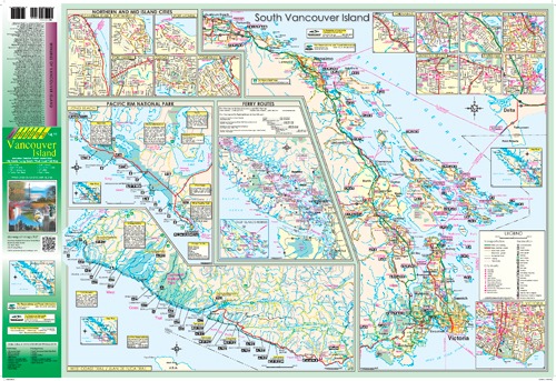
For U.S. travelers, understanding ferry routes is vital for reaching and navigating Vancouver Island, and a map clearly illustrates these connections. BC Ferries operates extensive services connecting Vancouver Island to mainland British Columbia, with major terminals at Swartz Bay (serving Victoria), Duke Point (serving Nanaimo), and Departure Bay (serving Nanaimo). These routes are prominently marked on travel maps.
Additionally, maps will show the international ferry service provided by the MV Coho, connecting Port Angeles, Washington, directly to Victoria's Inner Harbour. This route is often preferred by U.S. visitors coming from the Olympic Peninsula. Familiarizing yourself with these ferry terminals, their locations, and the routes they serve is crucial for planning your arrival and departure from the island.
When reviewing a Vancouver Island map, look for the designated ferry symbols and route lines connecting the island to the mainland and other smaller islands. Understanding these links allows you to select the most efficient and convenient ferry for your travel plans, whether you are driving a vehicle or traveling as a foot passenger. A map makes the complex network of ferry travel clear and manageable for all U.S. visitors.
Vancouver Island travel map, ferry routes to Vancouver Island, Victoria BC map, Tofino BC map, Vancouver Island attractions map, driving directions Vancouver Island, map of Vancouver Island cities, outdoor activities Vancouver Island map


Map 0f Vancouver Island Map Of Vancouver Island . AVICC 2026 Convention In Victoria This Weekend Island Social Trends Map . Vancouver Island Map The Little Canadian Map Shop . Little Huson Caves Guide North Vancouver Island Off Track Travel Vancouver Island Map 1000x609 . Vancouver Island Map Etsy Il Lyke


Maps Of Vancouver And Vancouver Island Vancouver Island ITMB Map Vancouver Island BC Wall Map Backroad Mapbooks 5150139 . Vancouver Island Road Trips Itineraries Day Trips To Week Long Loops Itinerary Map Cover Photo.webp. Vancouver Island Map Printable Vancouver Island Road Map . Vancouver Island Map The Essential Geography Of Vancouver Island Vancouver Island Map Essential Geography . Map Of Vancouver Environment Region In Canada Welt Atlas De Karte 7 916


Bridge To Vancouver Island Map Vancouver Island Rail Corridor Route Map . Vancouver Island Map The Little Canadian Map Shop VI1 . VANCOUVER UND VANCOUVER Island 2026 2026 DIN A3 Quer Vancouver Und Vancouver Island 2026 2026 DIN.webp. Traveling Maps Of Vancouver Islands Map Of Vancouver Island Gigapixel Standard Scale 1 25x . Vancouver Island Location C2d5e




Map Of Vancouver Island Bc VPO Vancouver Island BC North Map 2nd Not Applicable 4 10f2d421 75ec 490d 9339 . Vancouver Island Map Stock Vector Image Art Alamy Vancouver Island Map H2BGRA . Maps Of Vancouver And Vancouver Island Map Of Vancouver Island. Vancouver Island Location Vancouver Island Road Trip Map . Map Of Vancouver Island Bc Vancouver Island Lakes Map


Vancouver Island Map Vancouver Island Map . Map Of Vancouver Island Island In Canada Welt Atlas De Karte 7 744 . Detailed Map Of Vancouver Island For Fall Trip Map Of Vancouver . Vancouver Island Map Vancouver Island Map . Vancouver Island Facts And Map Birds Of A Feather B B Vancouver Island Map Bc




Highlights Of Vancouver Island 2026 2027 Small Group Tour Highlights Of Vancouver Island . The Difference Between Vancouver And Vancouver Island 2026 Location 2 . Vancouver Island Davenport Maps Ltd Vanisle Coverside . Vancouver Island Tourist Attractions Map Com Map Vancouver Island . BSides Vancouver Island 2026 InfoSecMap Conference Default 1024x683


Vancouver Island A Photo Memoir Victoria Sidney Nanaimo British Map2 . Detailed Map Of Vancouver Island Vancouver Island Sunshine Coast Map Vancouver Island Road Map . U Mista Cultural Centre Potlatch Museum In Alert Bay Cormorant Island Umista Cultural Centre.webp. Map Of Vancouver Island Vancouver Island News Events Travel Vancouver Island . Vancouver Island And Sunshine Coast Self Drive Tour 2026 Dates Prices 576 Canada Vancouver Island And Sunshine Coast Self Drive 20210830